MADFIG Projects
Soil Management Project
The Merredin and Districts Farm Improvement Group (MADFIG) was successful in receiving $89,348.00 through the Federal Governments National Landcare Program-Smart Farms Small Grants initiative to deliver a soil management project that focused on using remotely sensed and on-farm data to improve soil management in Western Australia’s eastern Wheatbelt.
The project commenced in September 2018 with Joel Andrew from MapIQ contracted to coordinate the study over two years, with completion being May 2020.
Eight farmers, who manage more than 42,000ha, carried out activities that mapped production zones across their properties, identified soil constraints that would limit plant production and then implemented paddock scale trials to assess various management options aimed to provide a better soil health and management outcome for that production zone.
Growers combined crop yield data with airborne radiometric soil maps and satellite NDVI to create farm production zones in each paddock. Deep soil testing was carried out within these zones to identify physical and/or chemical soil constraints that would likely result in reduced farm production because of inefficient use of applied inputs and soil moisture.
Alternative soil management practices that would likely improve soil health and farm production were then trialled by each grower. Growers selected zones to trial alternative practices based on the outcomes of the previous project activities where zones of below average production were identified and the reasons for this under performance uncovered.
In total 24 paddock scale trials were carried out across different productions zones and soil types in an effort to demonstrate how the different soil constraints present could be better managed. The on-farm trials consisted of nine variable rate input trials, seven lime rate or lime type trials, five deep ripping trials, two gypsum rate trials and 2 crop or pasture system trials.
The variable rate input trials consisted of variable rates of potassium, phosphorus or nitrogen being applied to crops at various times in the season and demonstrated to growers how technology could assist in assigning the appropriate rate of input to the production zone created in activity one.
The crop type system trials were developed to assess if a more appropriate crop or pasture species would grow better in that area given the soil constraints identified. All other trials were designed to demonstrate and assess if the soil constraints identified in activity two could be removed through the chosen trial.
The trial yield and economic results allowed growers to evaluate and quantify the value of different soil management techniques within their own environment. This approach give a greater insight into which technique would work best in their farming business and the confidence to implement that practice.
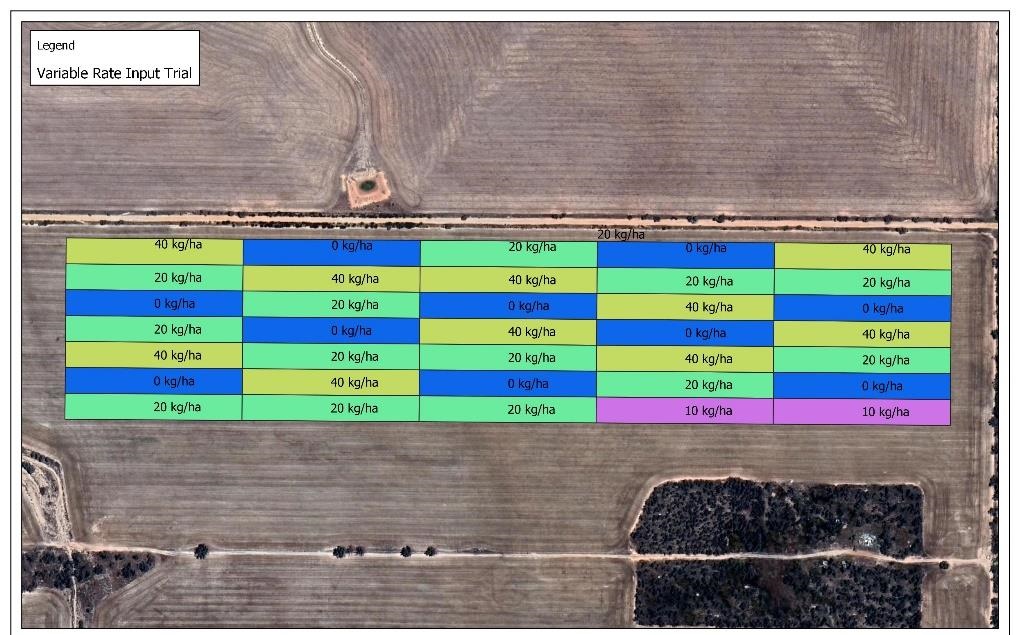
Figure 2: An example of a variable rate input trial that growers used to assess better management options
Both the growers that directly participated in this project and the additional members of the associated eastern wheatbelt grower groups have increased their awareness of a range of practices that lead to increased soil quality, soil health and farm productivity and have gained knowledge in how to use novel sources of data to map production variation and assess their current land use suitability.
This project effectively demonstrated to growers the process of combining their own farm data with remotely sensed data to identify production zones that are performing below average, to then determine the cause of this reduced performance and then use that information to determine the best management option to either remove the cause of under performance or manage that zone in a more appropriate way. Growers will use the techniques learnt in this project and apply the same process to other areas of their farms and businesses.
Specifically, growers have been provided an opportunity to trial variable rate technology, acquire and use remotely sensed radiometric soil maps and satellite NDVI imagery, evaluate different lime types and rates, compare and evaluate deep ripping machinery and trial farm data management software. All growers have said that they have already incorporated at least one of the demonstrated practices from this project into their farm business.
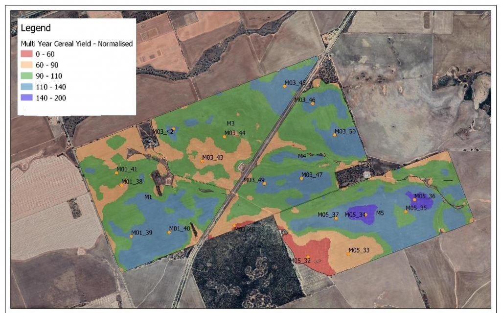
Figure 1: An example of production zone mapping and soil testing locations to identify soil constraints
Become a Sponsor
MADFIG cannot succeed in it’s mission without the support of its valuable partners.
Annual sponsorships are available for purchase.